The degree of damage due to a strong earthquake is often described by the macroseismic intensity, which is determined after the evaluation of the macroseismic questionnaires. Since a more objective measure of ground shaking is preferred by scientists (seismologists, engineers, urban planners, etc.), accelerographs are manufactured to provide an instrumental measure of the ground shaking at a specific site. Thus, by using strong motion records, scientists want to understand the effect of the source-to-site path, as well as the one of the local geological conditions on the formation of the shaking. The macroseismic and the accelerographic data are used to improve the earthquake resistant codes and to design earthquake hazard maps.
History
Acropolis Array

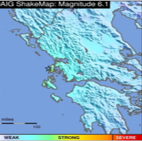
Shake Maps
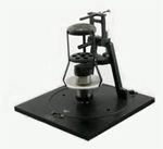
The strong motion instrumentation program in Greece started in early 70’s within the project “Balkan region seismicity study”. The Institute of Geodynamics installed 2 SMAC-B accelerographs, which quickly were replaced by a network of 15 SMA-1 accelerographs. This first network aimed to replace 17 seismoscopes (SR-100 Wilmot), which were installed in western Greece during the early 60’s, in order to correlate the macroseismic intensity with one physical quantity of the earthquake strong motion.
Since 2006, the Institute of Geodynamics in cooperation with the Acropolis Restoration Service (YSMA) has deployed an accelerometric array of 10 instruments. The complex geological conditions, the topography and the human earthwork interventions (filling materials) affect the modulation of ground motion. This instrumental seismic monitoring within the area of the Athens Acropolis records the effects of earthquakes on the monuments and results in extracting useful information concerning their response and furthermore the dynamic properties of materials.
This is an automatic service provided by NOA Institute of Geodynamics. It uses the USGS ShakeMap software and all the available seismic data at NOA Institute of Geodynamics in real time. In a later stage, the produced maps are updated combining also equivalent measurements/results produced by the Institute of Engineering Seismology and Earthquake Engineering (EPPO-ITSAK).